One of the emerging technologies set to change how road networks are managed is LiDAR. While not a new technology in itself, next-generation LiDAR applications will enable road agencies to better leverage intelligent transport systems.

To learn more, netBI interviewed the Principal of Intelligent Transport Services Pty Ltd, David Johnston (pictured left).
David is an experienced engineer and consultant with in-depth knowledge of traffic management who has been working on, and providing specialist advice on, the development and implementation of intelligent transport systems, since the early 80s.
Q. What is LiDAR?
LiDAR stands for ‘Light detection and ranging’ and is essentially a laser-based radar. A common type of LiDAR sensor is a spinning design which has a number of lasers that spin around inside the device at 10 times per second capturing images from different angles.
As the lasers spin and hit a solid surface, they reflect some light back to the unit. The unit measures the amount of time the light takes to travel, and from that determines a point in 3D space that signifies a surface. We can then convert clusters of ‘points’ and their coordinates to identify objects, and also track where and how each object is moving, very accurately.
Q. Why has LiDAR recently become more relevant for traffic management?
LiDAR is used by most Automated Vehicles to help navigate by providing high confidence detection of any obstructions, to measure the space around the vehicle and build a 3D view of the environment around the vehicle. Billions have been invested in the development of LiDAR sensors and the associated software tool chain to make this work.
New LiDAR object models that build on AV sensor technology are opening up opportunities to capture data for traffic management that haven’t been there before.
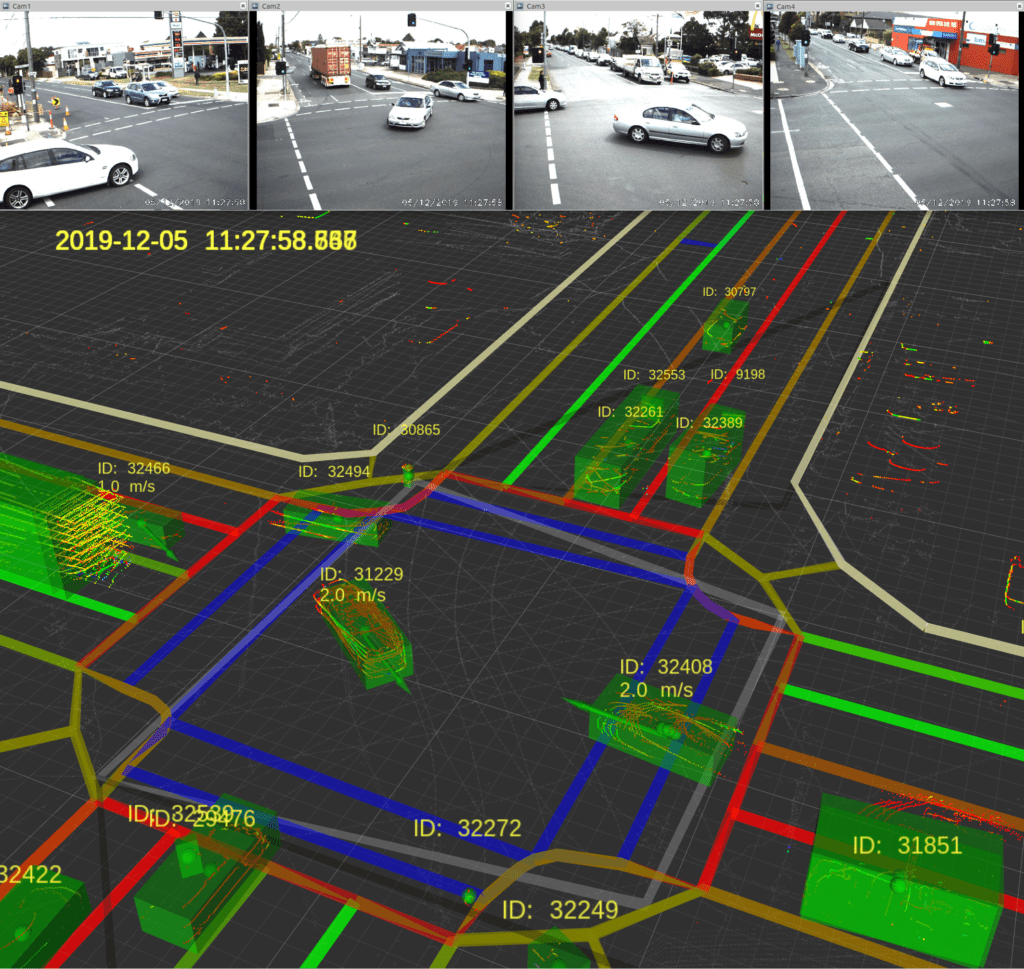
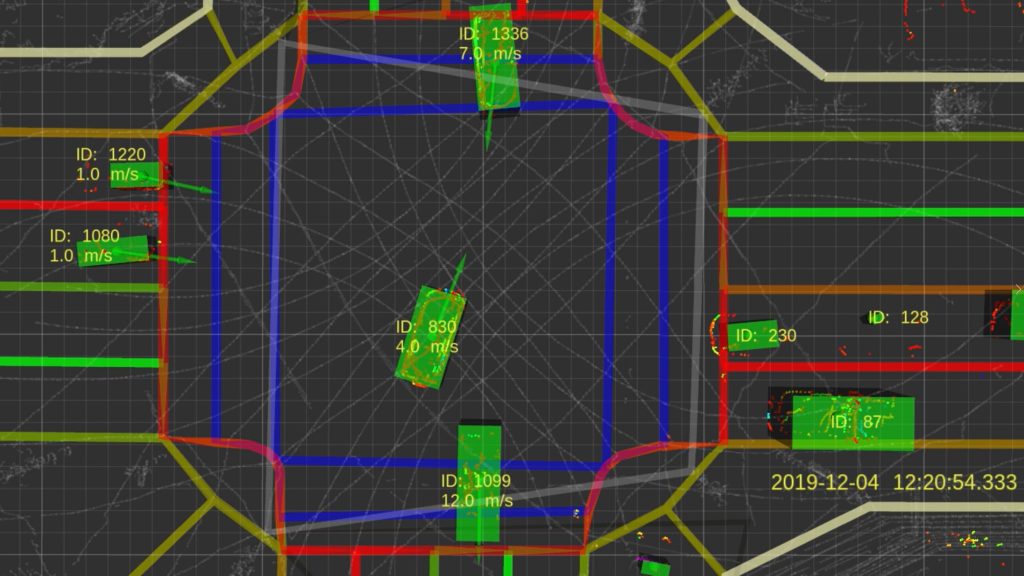
I recently completed a project together with a company called Omni-Aware that adapted those AV technologies for use on the roadside network. It’s a first for Australia, funded under the Victorian Government’s Towards Zero Road Safety Action Plan. The project installed LiDAR sensors at the corners of an intersection known as a crash hot-spot to capture a real-time model of everything moving through the intersection, and up to 100m on each approach.
It’s a potential game-changer for traffic management because LiDAR produces the highest quality data set available for an intersection.
Q. What advantages does LiDAR have over real-time video feeds?
It’s all around data certainty. Video cameras capture a 2-dimensional set of coloured pixels and need to interpret that to identify 3-dimensional objects. You can get an idea of the dimensions within an image, but there are problems with shadows, reflections, depth perception, and occlusion, such as when a large truck obscures the visibility of a motorcycle rider from a single camera sensor.
With a multiple LiDAR system, we can see all sides of the truck, plus other vehicles, riders and pedestrians on the footpath—it’s all there in the millions of point cloud data collected by sensors. Collectively, these 3-dimensional points give a centimetre-accurate view of every moving and stationary object at the intersection that is 100% trustworthy.
Another advantage of LiDAR over video is that road users remain completely anonymous so there’s no privacy concerns. LiDAR doesn’t tell you who a person is, but video potentially shows you their face.
Q. LiDAR has been around for decades. Why isn’t it already used by road agencies?
Currently, most roads rely on detectors that are loops of wire positioned in a shallow cut in the road surface, which works like a metal detector—only when a car is sitting above the loop is it ‘detected’ and a signal is sent to a control centre. The current paradigm only answers a question: at this instant, is there a vehicle on that patch of road?
Historically, loops have been the cheapest and most reliable option. Where loops become more expensive is during installation or maintenance because the lane has to be closed. This incurs the increasing costs of traffic control for the road authority and travel costs for the public.
Historically, LiDAR has been expensive. But as LiDAR is being used for more and more applications, the costs are coming down dramatically. The next-generation of LiDAR is based on solid-state technology, which will ultimately be cheaper and more reliable still. The autonomous vehicle industry will continue to drive the price of LiDAR down, but there’s opportunities for infrastructure-based solutions in the meantime.
Q. What’s the benefit of a more accurate view of what’s happening on roads?
So, you can see how a higher-quality set of data could lead to better decision-making about how to control roads and get the best performance. It’s effectively a quantum leap in intelligence for decision-making at intersections or along a section of motorway.
Another key outcome is knowing more about vulnerable road users. In the past you needed special detectors to detect push bikes, and pedestrians were only detected if they pushed the button at a crossing. LiDAR allows us to identify and track these users to better understand their needs and keep them safe. Road agencies could use the data to consider how to change traffic signals to accommodate and encourage ‘active transport’ to further reduce congestion.
For example, in the project I’m working on now, we used the LiDAR data collected at an intersection to pinpoint exactly where people step off the curb to cross a road—giving a complete picture of how people actually move around an intersection.
It helps underpin evidence-based approaches to creating safer roads and can give investigators more information about what happened if a crash occurs.
We detected a three-car crash at the project site where we had installed LiDAR sensors, and we were able to analyse exactly what happened by measuring the pre-impact spacing and impact speeds of each vehicle. So we knew the speed the rear car was travelling when it hit the rear-end of the middle car, which was propelled forward to hit the third car in front.
In the past, improvements to intersections for safety have been based on crash injury and fatality data—but unfortunately that can take years to collect and detect trends. If you open a new intersection and a crash occurs soon after, right now you don’t know if that’s a one-in-30-year event or a one-in-3-year crash. By the time you know, the community has already paid a significant price.
The system we’re developing using LiDAR enables agencies to identify near-misses and swerves, unsafe practices, and other indicators of a serious safety issue, much sooner.
Q. What are the data management implications of using LiDAR to capture richer data?
The object model I’m involved in developing produces the most comprehensive and granular road data set that is currently available. Because we’re collecting more and better information, there’s also more opportunities to explore the data.
This is where the capabilities provided by netBI—to be able to store, analyse, visualise, and quickly report on this large volume of data—is so important. With an effective data analytics platform you’re limited only by your imagination when it comes to querying the dataset. netBI’s platform will also allow for the development and training of AI and ML algorithms to continually improve the detection and analysis of road incidents and near-misses, and automate many tasks related to traffic monitoring and reporting.